MAP VISUALIZATION IN PAW

How to Enable Map Visualization in PAW?

A Map Visualization gives regular but an intelligent design to the data based on Geographical Template. In order to accomplish the above-mentioned requirement, a Modeler/Analyst needs to take care of certain things while developing the dimension and cube.

To create Map Visualization the view must include a defined geography dimension and this dimension needs to be in the Row axis of the view. There is a limitation of having only 3 measures in the column axis of a view. The geography dimension can be for E.g. Organization/Region/State/Location. The elements which are added in this dimension should be identifiable as geographic entities. There could be cases wherein Location codes are added in the dimension instead of actual names. In such situation, “Map” option will not be populated and we need to enable this option.

Steps: –

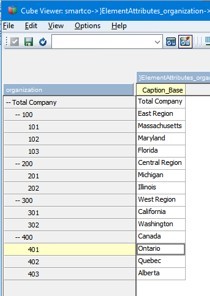
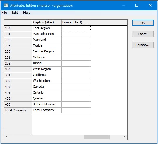
Add Element names in the Dimension as Actual names of a Region it could be Cities, States or Countries. If Dimension elements consists of Location codes instead of actual names then create Alias for the respective codes using }ElementAttributes.

  • Define the dimension as a geographic dimension for this, locate and open the }DimensionAttributes control cube. At the intersection of the dimension that you want to define as a geography dimension and the Dimension_Type attribute, enter Geography.

Now, Map option would be visible under “Change Visualization”.

Points to Remember: (Map Visualization)?

  1. The Planning Analytics Workspace needs to analyse 80% of the elements of the Geographic Dimension as geographic entities in order to generate map in “Change Visualization”.
  2. Geographic Dimension should be placed in the Row axis of a View.
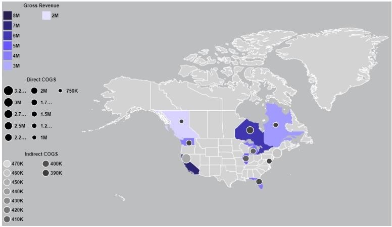
  3. A Map Visualization can display up to three measures only.
    1. Single-Measure map shades the region based on the measure data values.
    1. A Dual-Measure map shades the region based on the first measure, and for second measure it creates a sized-bubble on the respective region. Sized-Bubble means data value of that second measure for the region will derive the area(size) of the bubble.
    1. A Triple-Measure map shades the region based on the first measure, shows bubbles sized by second measure on each region, and shades those bubbles based on the third measure.
28 thoughts on “MAP VISUALIZATION IN PAW”
  1. How to get different geographic flags as a option on a country site or map? Any advises ?

  2. Right now it appears like BlogEngine is the top blogging platform out there right now.
    (from what I’ve read) Is that what you’re using on your blog?

  3. I really like your blog.. very nice colors
    & theme. Did you design this website yourself or did you hire someone to do it for you?
    Plz reply as I’m looking to construct my own blog and would like to know where u got this from.
    thank you

    my web blog … joker888 agent

  4. Hey there excellent blog! Does running a blog similar to this take a great deal of
    work? I’ve no knowledge of coding but I had been hoping
    to start my own blog soon. Anyway, should you have any suggestions or techniques for new blog owners please share.

    I know this is off subject but I just had to ask.

    Thanks a lot!

    Feel free to visit my homepage game 918kiss

  5. I do not even know how I ended up here, but I thought
    this post was good. I don’t know who you are but certainly you are going to a famous blogger if you aren’t already
    😉 Cheers!

  6. I’m gone to inform my little brother, that he should also pay a quick visit this
    webpage on regular basis to get updated from most recent information.

    Visit my web blog – 3win8

  7. With havin so much content and articles do you ever run into any issues of plagorism or copyright infringement?
    My site has a lot of unique content I’ve either authored myself or outsourced but it seems a lot of it is popping it up all over
    the web without my permission. Do you know any
    solutions to help reduce content from being stolen? I’d
    genuinely appreciate it.

    Feel free to surf to my web-site :: playboy2 download

  8. When someone writes an post he/she maintains
    the plan of a user in his/her mind that how a user can be aware of it.
    Thus that’s why this piece of writing is perfect.
    Thanks!

    My blog – ntc33 ios

  9. Hello there, just became aware of your blog through Google,
    and found that it’s truly informative. I am going to watch out for brussels.
    I will appreciate if you continue this in future.

    Many people will be benefited from your writing.
    Cheers!

    My web blog: id test ace333

  10. I am really loving the theme/design of your blog. Do you ever run into any
    browser compatibility problems? A small number of my blog audience have complained about my
    blog not operating correctly in Explorer but looks great in Opera.

    Do you have any solutions to help fix this problem?

    My web page :: 1 lpe88

  11. Excellent site you have here but I was wanting to know if you knew of
    any user discussion forums that cover the same topics discussed here?
    I’d really like to be a part of community where
    I can get responses from other experienced people that share the same interest.
    If you have any recommendations, please let me
    know. Many thanks!

    my web page: id akaun test 918kiss plus

  12. Today, while I was at work, my cousin stole my apple ipad and tested to see if
    it can survive a 40 foot drop, just so she can be a youtube sensation. My apple ipad is now broken and she has 83 views.
    I know this is entirely off topic but I had to share
    it with someone!

    my webpage: epicwin Original

  13. Hello! This is my first visit to your blog! We are a collection of volunteers and starting a new initiative in a community in the same niche.
    Your blog provided us useful information to work on. You have done a marvellous job!

    My blog post; gem 918kiss 2

Leave a Comment